The New Zealand Great Walks are a collection of 11 multi-day walking tracks across the country. On almost every track you can maximise your hiking experience by going with a guided walk tour operator.
How Did the New Zealand Great Walks Start and Why?
In order to protect the integrity of conservation assets, the New Zealand Great Walks network was created in 1992. So, 2022 marks the 30th anniversary. Since then, completing a Great Walk has become a cultural rite of passage. Not just for Kiwi hikers but for hiking enthusiasts from all over the globe.
Many of these tracks were originally used by early Māori. Followed by European explorers, then by deer-cullers and bushmen in the early days of New Zealand as a British colony. As walking became more of a national pass time, New Zealanders began to use these tracks for recreation. In the 1980’s the New Zealand Forest Service began to construct a series of back country huts along these tracks, providing emergency shelter and accommodation for outdoor users. The Department of Conservation selected a series of extraordinary and notable walks and dubbed them Great Walks.
What Makes It A Great Walk?
Most of New Zealand’s Great Walks are contained within National Parks. For a walking track to be given ‘Great Walk’ status by the Department of Conservation it has to be something extra special with a unique set of attributes. A Great Walk will take you through an area of special significance for its biodiversity, landscape scenery and cultural value. The Great Walks receive large amounts of ongoing funding, maintenance and promotion therefore you can expect a top-quality outdoor experience. The tracks will be well-formed and easy to follow with abundant facilities along the track
The 11 New Zealand Great Walks In Order from North to South
What Are The North Island Great Walks?
There are 3 Great Walks in the North Island of New Zealand. Two of these North Island Great Walks are traditional walking tracks completed on foot. The third is actually a river canoe journey down the Whanganui River with very little walking required.
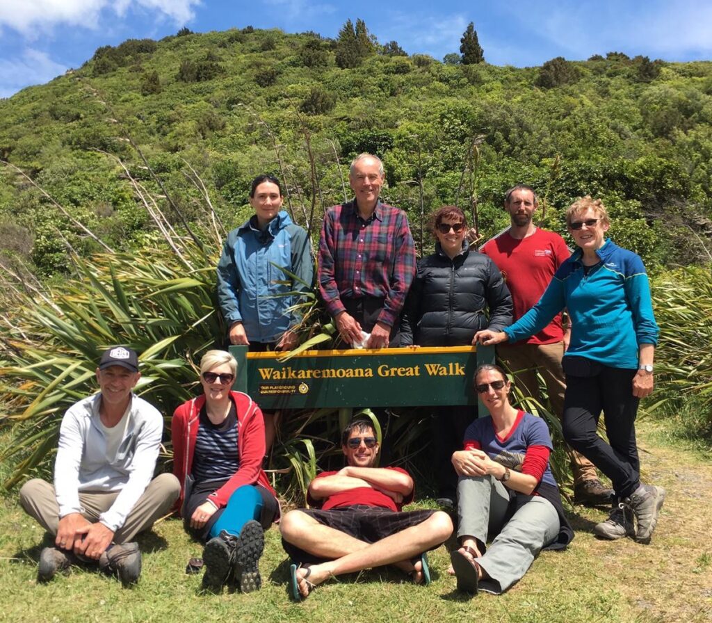
- Lake Waikaremoana Great Walk, Te Urewera
- Tongariro Northern Circuit, Tongariro National Park, Ruapehu
- Whanganui River Journey, Whanganui National Park
What Are The South Island Great Walks
- Heaphy Track, Kahurangi National Park
- Abel Tasman Coast Track, Abel Tasman National Park
- Paparoa & Pike29 Memorial Track, West Coast
- Routeburn Track, Mt. Aspiring National Park
- Milford Track, Fiordland National Park
- Kepler Track, Fiordland National Park
- Humpridge Track, Tuatapere, Southland
- Rakiura Track, Stewart Island
Lake Waikaremoana Great Walk, Te Urewera – Eastern North Island
44km I 27 miles I Seasonal I Water Taxi Transport Available I No mountain biking
Whilst most walkers follow the Department of Conservation advice to begin this walk at Onepoto and finish at the water-taxi pick up spot near the site of the (now burnt down) Whananui Hut, an easier approach is to start at Hopuruahine and finish at Onepoto. This way you’ll do the climb up Panekire Bluff near the end of the trip, with a much lighter pack.
Taking between 3 – 4 days this track follows the shore of Lake Waikaremoana, the North Island’s deepest lake. When the lake was formed, it filled up an ancient river valley. So the lake shore trail climbs up and over many of the old valley ridges making for an undulating track of moderate grading.
Enjoy spectacular views from Panekire Hut at the top of Panekire Bluff, which sits 600m above lake level and relish a walk along Panekire Ridge through a goblin-like cloud forest of dripping ferns and tree moss.
Te Urewera is home to the Ngai Tuhoe people who, in 2014, re-assumed governance of Te Urewera, their ancestral homeland. Te Urewera became the world’s first natural area to gain the rights and privileges of personhood, therefore owning herself but under the kaitiakitanga (guardianship) of her indigenous people.
Lake Waikaremoana Guided Great Walk
Is there a guided walk option on the Lake Waikaremoana Great Walk? Walking Legends is the only guided walking and hiking tour operator at Lake Waikaremoana. We offer a comfortable, lodge-based guided hiking tour experience called the Waikaremoana Discovery Tour. We don’t walk the entire Great Walk track, just the highlights section from Onepoto to Panekire Bluff. This is the easiest, most comfortable and fully supported way to hike at Lake Waikaremoana.
Tongariro Northern Circuit, Tongariro National Park, Ruapehu – Central North Island
43km I 27 miles I Loop Track I Volcanic Area I No mountain biking
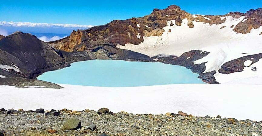
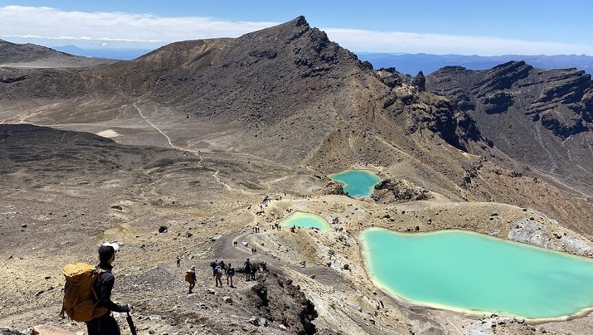
The Tongariro Northern Circuit traverses a phenomenal volcanic landscape in the heart of the North Island of New Zealand. This track is a loop so you can start the track in any direction, but the most sensible approach is to begin at Mangatepopo and finish up at Whakapapa Village. The full circuit begins and ends at Whakapapa Village, near the historic Chateau Tongariro Hotel. For a shorter option, begin the walk at Mangatepopo where the Tongariro Alpine Crossing begins. You’ll walk the bulk of the Tongariro Alpine Crossing, enjoy all the highlights of the world’s best 1-day walk before you turn east after Red Crater and drop down into the Oturere Valley towards your first night at Oturere Hut.
From Mangatepopo, the track climbs steeply up the valley and over the saddle between Mount’s Tongariro and Ngauruhoe. Mount Ngauruhoe played a starring role in the Lord of the Rings Trilogy as Mount Doom, recognisable by it’s almost perfect, conical shape.
Expect huge views, desolate lunar landscapes and high alpine weather conditions. This Great Walk is unlike anything else you’ll experience anywhere in New Zealand and is an absolute must-do on your North Island Great Walk mission.
Weather Alerts on the Tongariro Northern Circuit
Hint: Don’t underestimate the weather conditions on this track. Conditions can change quickly and become unsafe. Check weather reports before you go and pay attention to the Department of Conservation advice on track status each day – on bad weather days, the Department will close the track to all walkers.
Tongariro Northern Circuit Guided Great Walk Experience
For a guided walking experience, we offer a 3-day, all-inclusive guided walking package holiday on the Tongariro Northern Circuit. For further details check out our Tongariro Northern Circuit Great Walk hiking tour holiday package. This is an all-inclusive package, perfect for busy people who want to just show up and leave the hard stuff to the pros. We’ll collect you from National Park Village on Day 1 and get you back there safely at the end of Day 3. We supply all your meals, snacks and hot drinks while you’re on track with us. Your guides will carry the food and cooking equipment. You’ll just carry your own clothing, sleeping bag, water and any other essentials. We spend 2 nights in DOC huts, Oturere Hut then Waihohonu Hut. Our guides are First Aid trained and carry First Aid kits and emergency locator beacons. If you’re new to multi-day hiking or you’d just like the comfort and safety of a group around you, come with Walking Legends!
Whanganui River Journey, Whanganui National Park – Central North Island
145km I 90 miles I Tide-dependent at start
The Whanganui River Journey is a 4 – 5 day canoe trip along the Whanganui River, travelling through the Whanganui National Park. The route starts at Taumarunui and finishes at Pipiriki. There are over 200 rapids on the river, but none on this route exceed Grade 2. At 290km long, this is New Zealand’s 3rd longest river and it usually takes paddlers 5 days to complete the River Journey section, which covers 145km of the full river length.
In 2017, the Whanganui River followed Te Urewera in becoming the world’s 2nd natural area to achieve the rights, duties and liabilities of a legal person.
Guided Walks on the Whanganui River Journey
For guided tours of the Whanganui River Journey, try:
Heaphy Track, Kahurangi National Park – Top of the South Island
80km I 49 miles I Mountain-bikers only in winter
The Heaphy Track, in the Kahurangi National Park, is the longest New Zealand Great Walk. It is renowned for its huge variation in scenery over the 4 – 5 days required to complete the track. Most walkers begin in the Aorere Valley, west of Takaka, and finish up at Karamea on the West Coast.
As well as nikau, beech and tussock forests, expect sandflies in vast quantities as you reach the lower elevations at the river mouths near the coast.
Guided Walks on the Heaphy Track
For the best guided tours of the Heaphy Track, check out:
Abel Tasman Coast Track, Abel Tasman National Park, Top of the South Island
60 kilometres I 37 miles I Tidal Crossings I Open Year Round I Kayaking Alternative
Stretching from Marahau in the south to Wainui in the north, the Abel Tasman Coast Track is predominantly a coastal walking track. It is the most popular tramping track in New Zealand, with most of the approximately 200,000 visitors to Abel Tasman National Park walking at least part of the track.
The track is well sheltered with mild weather in all seasons and it is accessible and open throughout the year. Walking thYe track takes between 3 – 5 days depending on your approach as many points along the track are accessible by boat.
Expect a mixture of beach-walking to a soundtrack of gently breaking waves and frequent ups and downs as you climb up and over the many inlets and coves that characterise the Abel Tasman National Park.
Guided Walks on the Abel Tasman Track
For the best guided tours of the Abel Tasman Track, check out:
Paparoa & Pike29 Memorial Track, West Coast – Central South Island
56km I 36km I Dual hiking and mountain biking
Created as a memorial for the 29 miners who lost lives in the Pike River Mine disaster, this track is the tenth Great Walk to be created and has been fully open since 1 March 2020. It was the first addition to the Great Walks in 25 years.
In November 2010, a methane explosion at the Pike River Mine killed 29 men and trapped them. Family members of the men then worked with government and asked for a Great Walk and associated facilities to be built in the region not only to serve as a memorial but also as a source of revenue from tourism, compensating for the loss of income and employment the mine provided.
The track begins at Smoke-Ho carpark and finishes up at the Pororari River and includes some long days on foot. There is a conflict in the design of this walk between the requirements of hikers and those of mountain bikers. Enjoy huge views over the densely forested ranges of the West Coast, an area of high rainfall and sparse human habitation.
Guided Walk on the Paparoa Track
For the best guided tour of the Paparoa Track, check out:
Routeburn Track, Mt. Aspiring National Park – South-west South Island
32km I 20 miles
At just 32km, this is the shortest New Zealand Great Walk. The track spends a long time on the high ridges around Harris Saddle, with great long-distance views in many directions.
This area gets much less rain than the Milford Sound, and the forests are very different, especially on the eastern side of the saddle, which due to less rainfall is predominantly made up of New Zealand red beech and mountain beech, with relatively few ferns.
Access to the Routeburn Track is not as tightly controlled as the Milford Track. Camping is allowed, though both huts and camping spaces must be booked in advance during peak season. Because you usually tramp the track from one end and finish it at the other transport can be challenging: the distance between trail heads is 340 km (a 5-hour drive). Transport options include bus, hitchhiking or car relocation. Some people get around this by doing a key swap with another walker going in the opposite direction.
Guided Walks on the Routeburn Track
For the best guided tours of the Routeburn Track, have look at:
For Day-Walks on the Routeburn Track, try:
Milford Track, Fiordland National Park – South-west South Island
54km I 34 miles I No Direct Road Access – Water Transport Required
The famous Milford Track begins at the head of Lake Te Anau and crosses rainforests, wetlands and an alpine pass to Sandfly Point in Milford Sound.
During the summer peak season of late October to late April, access to the trail is highly regulated. Walkers must complete the track in four days, travelling only in the northward direction. Camping is prohibited on the trail. Walkers can tramp the track independently, or as part of a more expensive guided walk with a guide company. A maximum of 90 walkers can start the trail per day (40 independent, and 50 guided). Usually, these 90 places are booked out for many months in advance, despite the high cost of the guided walks.
Due to the one-way ticket system and limited hut capacities, trampers need to keep moving even during bad weather. During periods of especially heavy flooding, the DOC regularly calls in helicopters which fly trampers over flooded sections of the track.
Guided Walks on the Milford Track
For the best guided tours of the Milford Track, there’s really only one option in the marketplace – there may be a lot of agents or wholesalers selling this walk on behalf, but to book directly with the operator (the people who pick you up on Day 1), try:
Kepler Track, Fiordland National Park – South-west South Island
60km I 37 miles I Overland shuttle transport in summer only
This 3 – 4 day hiking trail follows a circular route through the Fiordland National Park and was originally designed to ease the strain of over-visitation on the Milford and Routeburn tracks. Most walkers begin at the Lake Te Anau Control Gates.
Keep an eye out for cheeky, but destructive kea, pesky sandflies and high-capacity bunk rooms in the Department of Conservation huts along the track. Don’t miss the Luxmore Caves near Luxmore Hut!
Guided Day Walks of the Kepler Track
The Kepler Track is hugely popular and one of the busiest South Island Great Walks. Hut beds book up within minutes on Open Day. The only accommodation option on the Kepler Track are Department of Conservation backcountry huts, no private lodges, therefore commercial guided walking companies are limited to day-walks (in and out). To walk the entire Kepler Track route, you’ll need to walk independently and unsupported by a commercial service, including carrying all of your own food and equipment. These companies offer guided day walks on sections of the Kepler Track.
Humpridge Track, Tuatapere, Southland – South South Island
61km I 37 miles I Construction in progress
The Humpridge Track opened in 2001 and is privately run by the Tuatapere Hump Ridge Track Charitable Trust. It has just become the newest New Zealand Great Walk, number 11. The Department of Conservation is currently working on lowering the gradient of some steeps areas of the track, adding timber boardwalks over boggy areas and converting it into a 4-day, 3-night walk instead of a 3-day, 2-night walk.
The track is a loop, beginning and ending near the town of Tuatapere, briefly crossing parts of the Fiordland National Park. Plan to spend around 3 days walking this track, over a variety of forested bushland and sandy, sometimes boggy, coastal track. You’ll experience dense coastal forests of rimu, miro, Hall’s totara and rata. The lower terraces are mainly podocarp and silver beech, while the higher terraces are dominated by yellow-silver pine. Birdlife includes the kākā, kea, yellow-crowned parakeet, South Island robin, fantail, bellbird, grey warbler and South Island tomtit.
Guided Walks of the Humpridge Track
For a guided walking option on the Humpridge Track, New Zealand’s newest Great Walk, check out:
Rakiura/Stewart Island Track, Rakiura National Park – Off the Southern Tip of South Island
32 km I 20 miles I Off-shore Island
This is a relatively easy, 3-day walk that can be completed in a loop fashion from Oban to Halfmoon Bay.
The track generally follows the coastline for a large part of its length, passing small inlets, large bays and mudflats, and crosses steep hills covered in thick forest in its middle section. In general, the track is well-maintained, and of easy to medium difficulty but some sections include very deep mud after heavy rain and gaiters are definitely recommended. Walking the track offers the unusual opportunity to see the tokoeka/southern brown kiwi, for which Stewart Island is famous for, in the wild. Most species of kiwi are nocturnal, but the tokoeka appears during the day time.
Guided Walks of the Rakiura Track
For a guided walking option on the Rakiura Track, New Zealand’s southern-most Great Walk, check out:
For all of your North Island Great Walk guided hikes, choose Walking Legends for an unforgettable New Zealand guided hiking trip!
To book a great New Zealand guided hiking tour in the North Island, visit our website now. Or speak to our friendly team to discuss your travel plans and which walk might be best for you:
NZ Freephone – 0800 925 569
AUS Freephone – 1800 646 584
International – 0064 7 533 3157
Or send an email to [email protected]