We walk the Pinnacles Track many times each summer as part of our 4-day Coromandel Explorer guided hiking tour. Our hiking guides know this track like the back of their hand. We’ve prepared a step-by-step guide to the Kauaeranga Kauri Trail ‘Pinnacles Track’ to help raise awareness of this excellent day adventure.
By far our favourite walk in the Coromandel Forest Park and one of our top 3 hiking trails in the North Island of New Zealand. This area of the Coromandel is steeped in fascinating pioneering history from the kauri-logging and gold mining days.

Where is the Pinnacles Track?
The Kauaeranga Kauri Trail is located just outside Thames township at the base of the Coromandel Peninsula. Around 40 minutes drive from the centre of Thames. It’s more commonly known as The Pinnacles. Set deep within the Kauaeranga Valley, at the southern end of the Coromandel Forest Park, this track is an epic full-day adventure. Here’s a Google maps link for driving directions to the Kauaeranga Kauri Trail.

What Does Kauaeranga Mean?
The word ‘Kauaeranga’ comes from the original ‘Waiwhakauaeranga’ which means ‘river of stacked up jaw bones.’ This name is so ancient that its origins have two different sources. Ngāti Huarere, an early Māori tribe, attribute the name to stacked up whale jaw bones, owing to the numbers of whales that stranded themselves in the Firth of Thames area. Another early Māori tribe with long links to the area, Ngāti Maru, refer to the name in the context of displacing Ngāti Huarere through intertribal warfare. Ngāti Maru invaded Ngāti Huarere, killed and ate them and stacked their skulls in a long row by interlocking the jaw bones. Either way, it’s not a name you quickly forget.
Accommodation for the Pinnacles Track, Coromandel
Looking for a convenient place to stay when you do the Pinnacles Track in the Coromandel? The closest service town is Thames. Here are some great accommodation options for walkers in Thames for your stay before or after you walk the Pinnacles Track in Coromandel.
- Grafton Cottages, 304 Grafton Road, Thames. Alby and Rachel are excellent hosts and offer a complimentary shuttle down to the bus station in Thames township.
- The Junction Hotel, 700 Pollen St, Thames. This is a working pub, so you won’t have to go far for a meal but expect live music on Friday or Saturday nights.
- Coastal Motor Lodge, 608 Tararu Road, SH25 Thames. Coastal Motor Lodge is 2.8km north of Thames township, or a 4 minute drive. It’s a great option if you’ve got a private vehicle.
- Lady Bowen Bed & Breakfast, 506 Brown St, Thames. Shared bathrooms. Conveniently located in the centre of Thames, easy driving distance from all Kauaeranga Valley and Coromandel Forest Park walking, hiking and tramping tracks.
How Do I Get to the Pinnacles Track?
The Kauaeranga Valley is a 1 hour, 40 minute drive from Auckland city or 2 hours 15 minutes from Rotorua. Public transport links like the Intercity bus service will get you to Thames, but not up the valley to the trailhead. We’d recommend you travel by private car or organise a shuttle through Biking and Hiking Shuttles for maximum flexibility. As most of the road up the valley is gravel, some rental car companies may object so check your contract first.
The Kauaeranga Valley Visitors Centre
From Thames, you’ll travel 14km up Kauaeranga Valley Road before reaching the Department of Conservation (DOC) Kauaeranga Valley Visitors Centre. The road winds into the Visitor’s Centre site and back out the other side, so just keep following the road. From the Visitors’ Centre you’ll carry on up the same road to the trail head. You can’t miss it because the road terminates here. The car park is wide and gravel surfaced. There are long-drop or pit-style toilets here and a picnic area.

How Hard Is It?
The track is rated as intermediate or medium grade. This means that the track is generally well-formed, some sections may be rough, muddy or steep. Tramping/hiking boots are strongly recommended, regular train runners or sports sneakers won’t serve you. All major stream crossings will be bridged so there’ll be no need to get your feet wet or to carry an extra pair of boots.
How Is The Track Marked?
In New Zealand, tracks are marked with orange triangles. All tracks in this area will be well signposted with poles or markers. The triangles point in the direction you should go. You may also see pink, blue or yellow triangles – these aren’t route markers, they usually mark where pest-trapping lines go. Follow only the orange markers. In areas where tree trunks are scarce, poles are used instead of orange triangles.
How Long Is the Track?
It’s a 15km walk, though we’ve measured it by various formats and we always get a slightly different result, so treat 15km as a fair average. A friend with a FitBit recorded taking 30,000 steps from start to finish. The track takes you up to an elevation of 759m over the course of 3 hours so you’re ascending, on average, 4 metres per minute.
Here it is mostly uphill with some steep sections. There are lots and lots of stairs, they aren’t continuous. Don’t worry, there are short breaks in between, but overall you’ll do a lot of stair climbing.
Expect to be stepping over a lot of tree roots, small boulders and rocks. This means you’ll probably be using a different set of muscles in your legs than you’re used to using on a flatter walking trail.
Will I Need Hiking Poles?
Yes! A pair of hiking poles are a great idea, particularly for the descent.
The Pinnacles Track
At The Trailhead
You’ll see a big green and yellow DOC sign at the entrance to the track. Take note of the information and maybe snap a photo for later reference. You’ll meet a boot washing station just inside the track entrance, this is to protect kauri trees in the area from kauri dieback disease. Please use the boot washing station when you enter and again when you exit. Scrub loose dirt from your boots with the brushes, then stamp on the mesh foot pedal, one foot at a time, to spray the underside of your boots with disinfectant. Make sure everyone in your party does this, it’s really important!

The First Part of the Track / Getting to the Base of the Ranges
Follow signs for ‘The Pinnacles Hut’ or ‘Hydro Camp via Webb Creek.’ The DOC sign at the entrance estimates a 3 hour walking and by this, they mean 3 hours to the hut and 3 hours back down, so a 6 hour return trip. We’ve taken many hikers on this walk over our 20 years of guiding and we find this estimate a really accurate reflection.
The track begins by gently wandering alongside the western side of the Kauaeranga River on a wide, well-maintained gravel surface. After 20 minutes or so, you’ll cross over the river via a bridge and walk along Webb Creek. Once you reach the end of Webb Creek the track begins to ascend noticeably after this point.

Table Mountain
As you head up the valley you’ll see a large, flat-topped mountain ahead of you to your left. This is Table Mountain and it’s higher than the Pinnacles at 846m elevation. While there is a tramping track to the summit of Table Mountain it’s extremely difficult and not marked on any topographical maps. Wilderness Magazine sent their hiking reporter to cover this track and he proposed it’s New Zealands’ Worst Tramp!
To Hydro Camp Via Stone Stairs
This trail was carved by bushmen and gumdiggers in the 1920’s who used packhorses and mules to cart goods up to the work camps. Workmen could spend up to 6 months straight living and working in this forest. Once a week a team of 8 packhorses would make their way up to the camps carrying supplies like flour, sugar, fresh meat and tinned food. To make things easier for the animals, they carved wide flat steps into the rock forming a unique staircase. The stair risers are taller than residential stairs as they were built for long horse legs, not humans. Take care in wet weather as the rock surface can get slippery and muddy.

Hydro Camp
This is the first point where the track widens out into an open, level area just perfect for a food and water stop. Hydro Camp is where workmen made camp for the night, to be better placed as to begin the next work day higher up in the ranges. There are wide logs placed conveniently here if you fancy a sit-down or you need to adjust your boot lacings. The ascent tends to separate fast walkers from slower walkers, so this spot is a great place to meet up again before tackling the next section.

From Hydro Camp the track begins another ascent, this time you’ll notice the forest becoming more sparse as you get closer to the top of the ranges. As you’re making your way up to the Pinnacles Hut, see if you can spot the original track running alongside the main track. Certain sections are visible, they are much more narrow and steep than the modern track you’re on. This is where the track starts to ‘bite in’ so it certainly helps to have a comparison as to what things were like ‘in the old days.’
Tauranikau
Keep an eye out for Tauranikau (elev. 703m), a beautifully rounded volcanic plug that will appear on your left, not far from the track. Volcanic plugs like Tauranikau used to fill up the central chamber of old volcanic cones. The sides of the cone erode away, leaving the plug in place.
Final Push to the Pinnacles Hut
Next, you’ll pass by the Rangihau track junction signpost but keep heading towards the Pinnacles Hut – you’re getting close now, only 10 minutes away! Thankfully, the hut seems to pop up out of nowhere, a very welcome sight.

The Pinnacles Hut, Coromandel
Set in a fantastic spot, the Pinnacles Hut, elevation 582m, is one of the largest in the 950-hut network in New Zealand. It has 80 bunk beds. Like most backcountry huts, it’s in the care of the Department of Conservation. Hut wardens are often present, they live here and work here in revolving multi-day shifts. If you’re lucky enough to arrive at the right time, you may be treating to a ‘hut talk’ where the warden shares stories and information about the immediate surrounds.
Many walkers come up to the hut to spend a night and head out the next day. Hut beds must be booked in advance, via the DOC website. Things get pretty crowded on Saturday nights and throughout the school holidays, so time your trip well to avoid peak nights if you can.
Facilities At The Pinnacles Hut, Coromandel
The hut has running water (cold water only) and more pit-style, long-drop toilets. If the weather is nasty, day-walkers are welcome to shelter inside the hut or on the wide, covered terraces to rest or refuel. There’s a supply of gas for cooking. You don’t have to take your own canisters. Mattresses are supplied here too.
Dancing Camp Dam
From the Pinnacles hut, a short side trail takes you down to Dancing Camp Dam. Built in 1924, it’s a fantastically well-preserved example of kauri logging dams. These kinds of dams were built by bushmen during the kauri logging boom on the late 1800’s and early 1900’s. There are many of these dams remaining in the forest, but most are not in good repair or easily accessible. This particular dam has been carefully restored so not all parts of it are original. Early pioneers used rudimentary engineering used to transport huge kauri logs from the tops of the ranges down to the valley floor and out into the harbour.

To the Summit of the Pinnacles
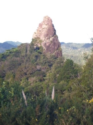
Reaching the hut is not the final destination of this walk! The track continues beyond the hut up to the Pinnacles peak at 759m elevation. A 30 minute push, straight up, from the hut puts you at to the top of the pinnacles rock formations. It’s steep but you’ll kick yourself if you don’t do this!
From the hut, follow the track up a steep network of wide, boxed timber steps to the base of the rock peaks. A tall metal ladder, with balustrading, safely encloses you as you ascend the first rock peak. Once you’re over the top, the track weaves through huge boulders, encasing you on either side, providing a welcome ‘lane’ through which to climb up. Pull yourself up a series of steel rungs set deep into these rocky boulders.

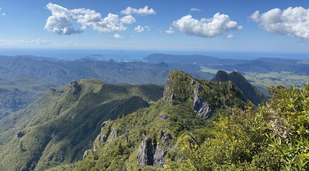
The track levels out briefly at certain strategic points. There is an excellent viewpoint where you’ll see a chain of point volcanic plugs, lined up like fence posts, with rounded tops. Like Tauranikau, these two were once part of ancient volcanoes. Over millenia, wind and rain have eroded them into the unique shapes of today.
What Will You See At The Summit?
You’ll come up onto a timber platform, enclosed with balustrades and handrails. This is the ultimate viewing platform and the terminus of the track. Enjoy spectacular views out over the Coromandel Forest Park. Look to the east and if the weather is clear you’ll see the town of Tairua down on the coast. If you look west you’ll see the roof of the Pinnacles Hut, and no doubt an ant-trail of hikers making their way up the steps behind you.

Wi-Fi & Cell Reception
The Pinnacles Hut is not great for cell reception, but the hut warden will have communications in the event of any emergency. We’ve found better service up on the wooden platform lookout or on the helicopter pad near the hut. It very much depends on your service provider as well. Because it’s so intermittent it’s best to be clear with your employer or whoever else might want to reach you that you’ll be unavailable!
Heading Down Again
There are two ways to get back to carpark. Firstly, via the same route you took to reach the summit and secondly via the Billy Goat track. The Billy Goat track is longer, more difficult and just not that much fun, so you’ll have a better experience if you take the same route back down.
Looking for Adventure Buddies?
If you’d like to come and do this walk but you find it hard to convince people to go with you, come and join one of our guided multiday walks! Our walkers are in their 50’s, 60’s and 70’s with one thing in common, they love to walk. For the perfect coastal hiking holiday, check out our Coromandel Explorer guided hiking tour, an all-inclusive package. We arrange accommodation, transport, meals and the services of a professional on-trail guide. All you have to do is show up with your gear! There are regular departures across the New Zealand summer hiking season from October to April (inclusive). See available departure dates for the Coromandel Explorer guided walk on our website.
To see more images of this great New Zealand walking holiday, visit the Walking Legends YouTube channel. If you’d like to keep up with our latest news, follow us on Facebook or Instagram.
The Mountain Safety Council of New Zealand has published this great informative video of the Pinnacles, with lots of helpful safety information.